Plate Tectonics Tourism: Standing on Two Continents at Once

Plate Tectonics Tourism: Standing on Two Continents at Once

James Chen

August 21, 2025

5 min read· 50 views
The story of plate tectonics is one of slow-motion drama spanning millions of years. Alfred Wegener first proposed the idea of continental drift in 1912, but it wasn't until the mid-20th century that the theory gained convincing evidence. Today, standing where the North American and Eurasian plates diverge gives a visceral sense of this colossal process. I remember arriving at Þingvellir National Park under a low-hanging mist, the sharp scent of wet moss and volcanic rock filling the air as I walked a narrow path wedged between two continents. The crack beneath my boots is the Mid-Atlantic Ridge slicing through Iceland, visible above water (a rare treat).

Scientific Milestone

1963: The discovery of symmetrical magnetic stripes on the ocean floor confirmed seafloor spreading, solidifying plate tectonics as the unifying theory of geology.

Þingvellir, Iceland - Walk Between Continents

Where North America and Eurasia Drift Apart
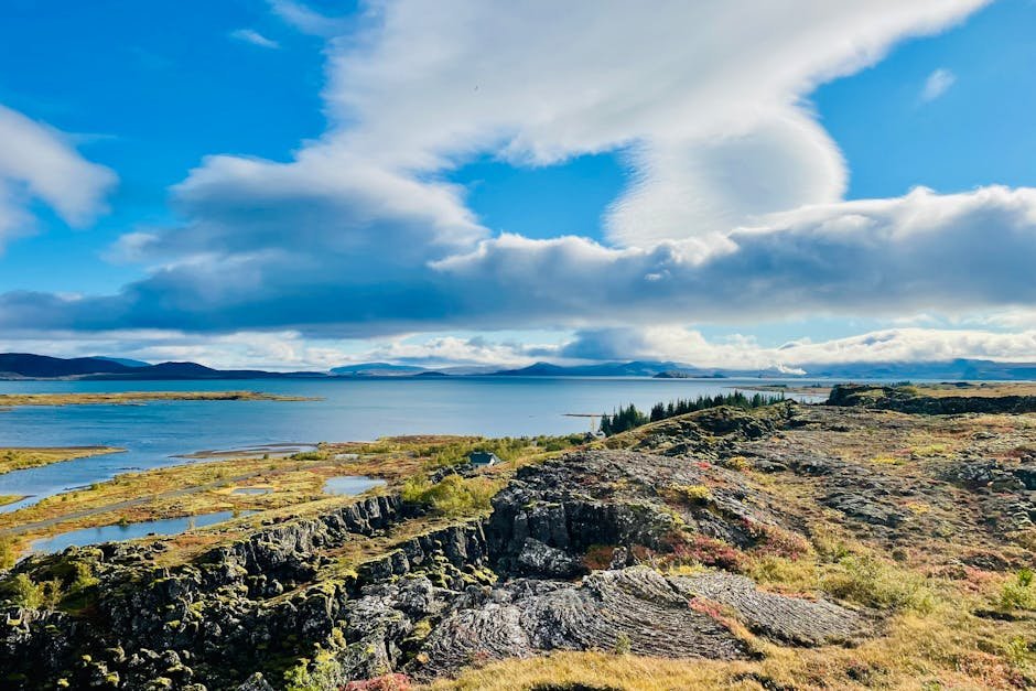
Stunning landscape view of Þingvellir National Park showcasing cliffs and lake under a blue sky.

Þingvellir Rift Valley

Þingvellir (pronounced Thingvellir) National Park is a UNESCO World Heritage Site where you can literally walk between the North American and Eurasian tectonic plates. The Almannagjá fissure is a dramatic canyon formed as the plates pull apart roughly 2.5 centimeters annually. Beyond geology, this site holds deep cultural significance: it was home to the world's first democratic parliament, Alþingi, founded in 930 AD. I recall my first glimpse of the crystal-clear waters of Silfra fissure, renowned for some of the clearest diving in the world, made possible by glacial melt filtering through volcanic rock.

Plan your trip with AI

Turn inspiration into a real itinerary. Plan day-by-day routes, find the best spots, and share with friends.

Geological Oddity

Iceland is the only country straddling the boundary between the North American and Eurasian plates, making it a natural laboratory for tectonic study.

Visiting Þingvellir is straightforward: open year-round with no entry fee, though a portion requires a small parking fee. The best time is late spring to early autumn when trails are accessible and daylight stretches long. Guided hikes are available, often with Icelandic geologists explaining the park's complex geology and history. Winter, however, transforms the park into an icy wonderland, though more challenging and requiring proper gear and caution.

Þingvellir Visitor Tips

  • 1

    Dress in layers - Iceland's weather shifts rapidly; waterproof jackets and sturdy boots are a must.

  • 2

    Try snorkeling in Silfra - book in advance; the water temperature remains around 2-4°C year-round.

  • 3

    Respect the fragile environment - stick to marked trails to preserve mosses and lichens that take decades to recover.

Lake Afar, Djibouti - Watching the Earth Split Apart

The Active African Rift Unfolds Before Your Eyes
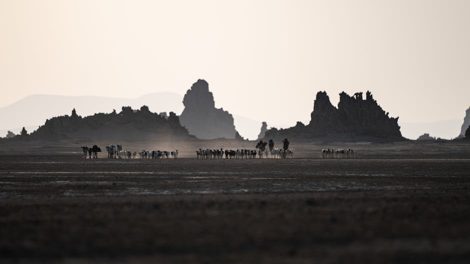
A herd of cattle traverses the dry plains of Djibouti, framed by rugged mountains at dusk.

Lake Afar and the East African Rift

Lake Afar, also known as Lake Assal, sits in the Afar Depression of Djibouti, a geological hotspot where the African Plate is actively rifting apart into three segments. The lake, the saltiest outside Antarctica, drains into a basin that's sinking several centimeters a year. I remember the dry heat, sharp salt tang in the air, and the distant rumble of volcanic activity as the ground flexed subtly. This place is one of the few on Earth where rifting is visible above sea level and progressing rapidly; a geologist's dream and an adventurer's thrill.

Extreme Conditions

Lake Assal lies 155 meters below sea level, making it the third-lowest point on Earth and the hottest place year-round in the Horn of Africa.

Accessing Lake Afar can be challenging; a 4x4 is essential due to rough terrain and extreme heat. Visiting during cooler months (November to March) is advisable to avoid oppressive temperatures exceeding 45°C. Local guides are invaluable for navigating the area safely, providing insights on the Afar people's way of life, who have thrived in this harsh landscape for millennia. The rift here, part of the larger Great Rift Valley system, demonstrates the ongoing breakup of the African Plate and the birth of a new ocean possibly millions of years from now.

Geological Fact

The Afar Depression is the only place on Earth where a mid-ocean ridge can be studied on land, where continental rifting is in its infancy.

Great Rift Valley, Kenya - Driving Along a Giant Crack

Exploring the Longest Rift on Earth
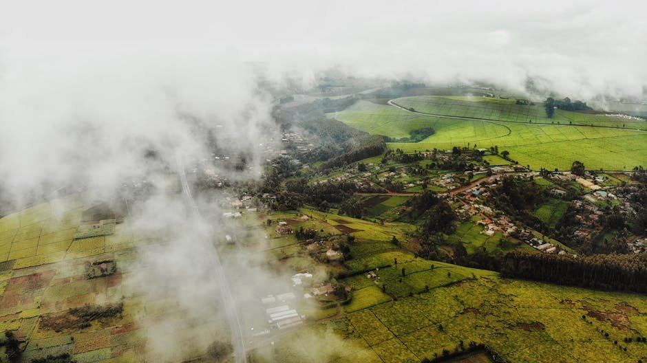
Drone view of green plantations and fields near village with buildings and trees in summer day under cloudy sky

Kenya's Great Rift Valley

Stretching over 6,000 kilometers from Lebanon to Mozambique, the Great Rift Valley in Kenya is a stunning corridor of volcanoes, lakes, and fault lines carved by tectonic forces. Driving along its length, I was struck by the sheer scale of the fractures in the Earth. The valley's lakes (Naivasha, Nakuru, and Baringo) shimmer with alkaline waters shaped by volcanic activity. The air hummed with wildlife calls and the scent of acacia and burning wood. This rift is both a geological spectacle and a cradle of human evolution, with fossil sites nearby revealing ancestors that walked this land millions of years ago.

Evolutionary Hotspot

The Great Rift Valley is one of the most significant fossil sites globally, providing evidence of early hominids dating back over 3 million years.

Visiting the Great Rift Valley can be tailored from budget camping trips to luxury safari lodges overlooking the rift's cliffs. The region is accessible year-round, though the dry season (June to October) offers the best wildlife viewing and road conditions. Guided tours not only cover the geology but also the rich cultural fabric of the Maasai and other tribes who have inhabited these lands for centuries.
YearEventSignificance
1912Alfred Wegener proposes continental driftFoundation of plate tectonics theory
1963Discovery of seafloor spreadingProof of tectonic plate movement
930 ADFounding of Alþingi at ÞingvellirWorld's oldest parliament establishes cultural heritage
1978Lake Assal surveyed in detailUnderstanding active rift processes
1920sGreat Rift Valley fossil finds beginInsights into human evolution

Planning Your Plate Tectonics Tour

  • 1

    Pack for extremes - from Iceland's chill to Djibouti's heat, versatile clothing is key.

  • 2

    Hire local guides - gain scientific insights and cultural context while ensuring safe passage through remote areas.

  • 3

    Respect natural and cultural heritage - these sites are dynamic but fragile environments with deep historical roots.

  • 4

    Budget accordingly - costs vary widely: Iceland entry is low-cost, Djibouti requires expense for transport, and Kenya offers options from budget camps to upscale lodges.

“
"The continents are like puzzle pieces, constantly moving and reshaping the face of our planet. To stand at these fractures is to witness the Earth's heartbeat itself." - James Chen
Standing on the seams of Earth's crust is a humbling experience: a reminder that our planet is alive, evolving, and sometimes violently restless. From the icy fissures of Þingvellir to the sun-scorched salt flats of Lake Afar, and the vast Great Rift Valley teeming with life and history, these places offer more than adventure; they offer perspective. Next time you plan a journey, consider not just the sights but the shifting ground beneath, where science meets the thrill of discovery in real time.

James Chen

Travel Editor at Vitano Magazine
You might also enjoy

Surfing Portugal's Silver Coast: From Ericeira to Nazaré
Adventure4 min

Surfing Portugal's Silver Coast: From Ericeira to Nazaré

If you’re chasing waves in Europe, Portugal’s Silver Coast is where it’s at. From beginner-friendly breaks to some of the world’s gnarliest big waves, this stretch between Ericeira and Nazaré offers a raw, salty ride alongside charming fishing villages, lively surf camps, and an endless Atlantic soundtrack. Pack your board, mate - we're hitting the road and the water!

DV
Diego Vargas
04/21/2026
Via Ferrata in the Dolomites: A Beginner's Guide to Iron Paths
Adventure4 min

Via Ferrata in the Dolomites: A Beginner's Guide to Iron Paths

At 2,500 meters above sea level, clipped into steel cables with nothing but a harness and your wits between you and a steep drop, the Dolomites’ via ferrata roads offer a raw, exhilarating taste of alpine adventure. Whether you're a first-timer or a hardened climber, navigating these iron paths rewards you with vertigo-inducing views, adrenaline jolts, and an unforgettable connection to the mountains. I’ve done 12 via ferratas here; this guide cuts through the hype with real-world insights on the best routes, gear rentals, rifugio stays, and what to expect when you sign on for your first climb.

MB
Marcus Berg
04/21/2026
Diving the Cenotes: Mexico's Underwater Cathedral
Adventure5 min

Diving the Cenotes: Mexico's Underwater Cathedral

Mate, if you ever find yourself cruising through Mexico’s Yucatán Peninsula and you’re craving a dive unlike any other, the cenotes are calling your name. These crystal-clear freshwater caves aren’t just beautiful; they’re a peek into ancient Mayan mythology and a playground for adventurers like me. I spent weeks exploring them, and honestly, every splash felt like entering an underwater cathedral carved by time.

DV
Diego Vargas
12/18/2025